Email notifications for live feeds
You can set up email notifications for your live feed by going to your Study page and selecting Live Feeds > Email Notification.
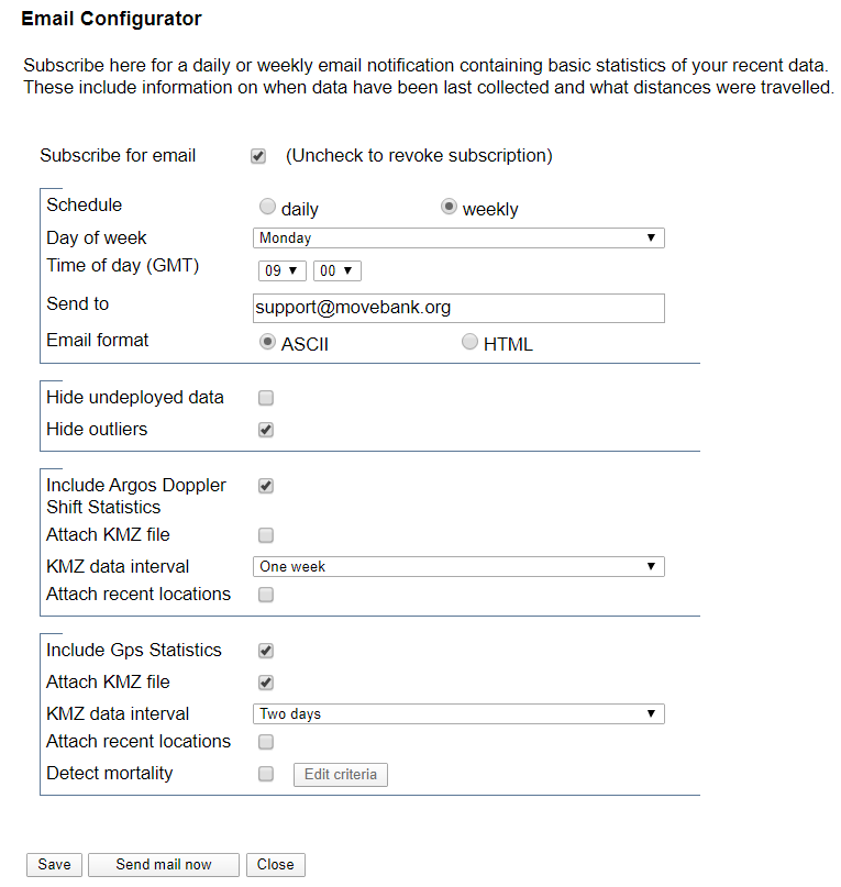
Statistics include information on the timing of the most recent locations and cumulative distance traveled in the previous day and week. Statistics are calculated for each animal with an active deployment. Settings offer a variety of options:
- Emails can be sent daily or weekly, at a chosen time, to one or more email addresses.
- Receive a KMZ (Google Earth) file containing locations for a specified period.
- If your tags contain multiple sensors (e.g. Argos Doppler and GPS), statistics and KMZ files can be provided for each.
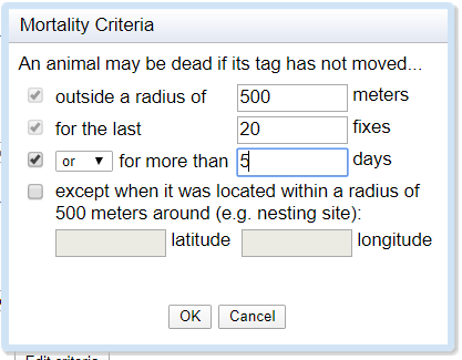
- For GPS sensors, you can also choose to detect possible mortality based on movement statistics.
The format of these email notifications is based on notifications provided to Argos users by David Douglas at the U.S. Geological Survey.
Email notification contents
An example of the email notification contents is shown below. Note that for Argos data, the statistics you receive will depend on whether you choose to hide outliers, along with your Argos filter settings (which are used to define outliers). Therefore if you have selected to hide outliers, the "last timestamp" will represent the last timestamp for a valid location, which is not always the same as the most recent message received from Argos.
GPS: Most Recent Data
| animal | tag | 24h | 2d | 4d | 7d | 15d | >15d | last timestamp | mortality |
|---|---|---|---|---|---|---|---|---|---|
| Arria | 300 | X | 2013-12-15 10:00:00.0 | alive | |||||
| Carna | 100 | X | 2013-11-18 16:42:56.0 | dead | |||||
| Juliet | 200 | X | 2013-12-15 10:05:07.0 | alive | |||||
| Omega | 400 | X | 2013-12-09 23:30:29.0 | alive |
X = Message with GPS location O = Message without GPS location ? in last column = no post-deployment data have been collected If the most recent message lacks locations, the most recent location is also displayed. Header "24h" means less than 24 hours back, "1d" less than 1 day and so on. Tag mortality: according to criteria defined; "n/a" indicates that number of fixes or time range was to low to confirm death.
GPS: Cumulative Distance Table
| animal | tag | dist24h | n24h | dist7d | n7d | avg7d |
|---|---|---|---|---|---|---|
| Arria | 300 | 50.92 | 5 | 284.03 | 24 | 11.83 |
| Carna | 100 | 0 | 0 | 0 | 0 | 0 |
| Juliet | 200 | 14.29 | 10 | 72.67 | 70 | 1.04 |
| Omega | 400 | 0 | 0 | 32.84 | 8 | 0.96 |
Cumulative distance (km) tracked in past 1 and 7 days.
Mortality criteria
As part of an email notification for GPS data, you can choose to set "mortality criteria" to identify if a tag has stopped moving, so that you can be notified of the possible death of an animal. Select Detect mortality from the email configurator options, and enter a radius outside which your animals should reasonably be expected to move within a specified time (in fixes and/or days). You can also specify a location where the animal might stay for long periods of time, such as a breeding site, as an exception to the criteria.
Create and manage live data feeds
Live feeds from Africa Wildlife Tracking
Live feed notifications